Showing posts with label hiking. Show all posts

Monday, April 26, 2010

Spring break 2: Sheep, waterfalls and mines

Day two of spring break found us right across the street from our hostel at Swallow Falls, a little boardwalk area that offered lovely views of one of the area's most beautiful waterfalls.


It was pretty, but I was a little bummed out they charged £1 to look at it from a distance, unlike the other waterfalls in the area that you could go right up to for free, given that you could find them off some of the hiking trails.

After admiring the water for a while, we rode the bus into town and spent the day hiking back up towards the hostel via the numerous hiking trails that branched off from the road.

By far, the most impressive trail we hiked was one that led over the Miner's Bridge, a unique steeply inclined footbridge used by the lead miners of the 19th century.  I didn't know this at the time though, until we later started stumbling upon "Danger Old Mine" signs, which you'll see further down.
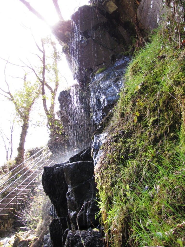

I was mostly impressed by the waterfalls, and had an absolute blast climbing around on the rocks and boulders and tree stumps strewn in the rapids. Again, the scenery and environment was just totally awe-inspiring and completely breathtaking.


We hiked around for a couple hours, further up the mountain. The trails literally went on for miles and miles, but we stayed within the 2-4 mile range (wisely, I think) and still saw a ton of stuff. Just above is the warning sign had mentioned earlier. As soon as I saw it I wanted to go off and look for the mine, but my friend wouldn't let me... :(

So instead we had lunch at another nearby waterfall we found nearby, before tackling the lengthy trail back to the hostel.


Much to my delight, on our way back I noticed some old ruins at the foot of a hill off the road and immediately climbed down to investigate further. Victory! I found my mine! It was fenced off, but I was happy.

Across the river was a slightly stranger part of it, as you can see above. Below some old mining equipment, water was pouring out of the side of the mountain and appeared to have dyed the rocks brilliant orange. The best I can conclude is that this is from the lead and minerals that were drawn from the mine and are still continuing to spill out.

After taking a break back at the hostel, we went for an evening walk up the road in the other direction we hadn't been yet (thus far, we had only been going to and from the town -- I was curious as to what was around the other corner!). We found lots more sheep fields, distant snow-capped mountains, and more hiking trails.


We hiked down one of them and found these absolutely adorable sheep. They all had identical black spots over their eyes and noses, and had the deepest "voices" I've ever heard! A few of them also had this really funny way of getting down on their front knees to graze. They would kind of just get down there and scoot along on their knees with their faces in the grass. Perhaps I'm way too easily amused, but I almost died laughing when I first saw it.

Alas, our second and final day in Wales came to an end. I suppose it was just the right amount of time to explore Betws-y-Coed, but I wasn't ready to leave Wales. Something about that place was so incredibly magical, I wanted to see more. I found it all so serene and inspiring, and completely exhilarating all at once. I know for sure I'll be returning to Wales some day to see the rest of the country.

I'll try to post days 3 and 4 soon!

Sunday, April 25, 2010

Spring Break 1: "You're in walking country now"

Snowdonia National Park is located in northern Wales, a country roughly the size of New Jersey and has literally more sheep than people (that's 3 million people and 11 million sheep, to be precise). As our final train chugged into Llandudno Junction, it was clear that this place was truly something special. Mountains rose in the hazy distance, forests blanketed the landscape, and sheep fields divided by crumbling stone walls followed the contours of the foothills for miles.

We were dropped off in the tiny town of Betws-y-Coed (pronounced BET-oos-uh-COYD, f.y.i.) by bus, which had about 2 main roads, and only one stop light that I could see.  I had a blurry map I'd printed out and walking directions from Google Maps, both of which quickly proved useless. We started out walking the wrong direction, so we stopped in at a hotel for help. The lady at reception hadn't heard of the Swallow Falls Youth Hostel, but she said Swallow Falls was about 2.5 miles up the road in the opposite direction. Google Maps had lied -- according to my print-out, it should have been .5 miles away. Oh well...

We walked and we walked and we walked some more. Figuring we had to have gone more than 2 miles, I was beginning to grow alarmed that the town was now far behind us and the road was weaving futher up into the mountains and forest, and the only remaining roadside buildings were B&Bs and farmhouses. I called the hostel for directions, and they said it was another 2 miles away. How could that possibly be? We must have walked 10 miles already! So we walked and we walked and we walked.

It felt like it had been hours and I didn't know what else to do. It was getting towards sunset, and, afraid of having to sleep in a sheep field for the night, I finally went up to a B&B and rang the doorbell. No one answered. I went next door and did the same thing. Thank goodness for the kindness of strangers, because a very nice woman answered and informed us that we were about a 20 minute uphill walk away. She said we looked very tired, but this was good for us because, as she said, "You're in walking country now."

And indeed we were. We continued up the mountain road and were relieved about 30 minutes later to see a sign indicating the hostel was about 200 yards ahead. We had made it. We powered up the last few hundred feet past another sheep field and finally checked into the hotel/hostel complex. It was a decent room (pictured above), made for 6 people but fortunately we were the only ones there.


The next day, after a £1 breakfast at the hostel, we rode the one and only bus into town and explored some of the trails and side streets. We found our way to a little suspension bridge, which led to a dead-end trail between two sheep fields.


The scenery was drop-dead gorgeous, everywhere we looked. It's just mindboggling to see that places as serene as Betws-y-Coed still exist, seemingly unchanged in the last 100 years but for a few refurbished buildings and new cars.
Above is the graveyard at St. Michael's church, an abandoned chapel on the river.

This was the train we rode into town... Just kidding! This is the actual rail station though, with a little kiddy train that runs around the adjacent railway museum.


Around mid-day we found the Pont-y-Pair Bridge, which crosses over a beautiful waterfall that cuts through the town. I couldn't help but think in the US this sort of thing would be fenced off and plastered with warning and liability signs and they'd be charging admission to see it, but here it was opened to whoever felt like clambering down amongst the boulders and cascading waters.

Another nice thing about Betws-y-Coed was that it only has a population of about 500 people and few tourists, so we pretty much had the whole place to ourselves. The only other visitors seemed to be either retirees from the nearby trailer park, locals, or serious backpackers, hikers and climbers.


We ended up following a forest trail for a mile or 2 along the river and through various sheep fields. Eventually we came back to town, had a late lunch/early dinner by the waterfall and took a leisurely 2 mile walk back to the hostel.

Thus ended my first day of spring break. Wales was already shaping up to be one heck of an adventure, and certainly one of the most beautiful places I have ever seen.

Wednesday, March 24, 2010

Ireland, day 7

Our seventh day in Ireland was the busiest day I had the entire time I was there. I'll try to let my pictures do most of the talking so as not to make this too long (I think it's already too late to worry about length though!).

We rode the city bus to Cave Hill Country Park, on the outskirts of Belfast, much like Colin Glen (although fortunately this time we had a friendly bus driver who let us off at the street leading up to it and gave us good walking directions from there!). Belfast is situated in the Lagan Valley and surrounded by gigantic hills -- being from Florida, I thought they looked more like mountains, but everyone insisted they were hills. We were over 1,000 feet in altitude though, so whatever you want to call it, that's what we were hiking.


Belfast Castle stands about a third of the way up. It's a 19th century mansion that was owned by the third Marquis of Donegall (a family who owned/owns much of the land in Belfast).


It was open to the public, but there wasn't much inside. Apparently it's mostly used for weddings and rented out for private events. On the top floor, there were some really old informational displays, including the large taxidermy exhibit above.

This was the view of the city from the castle.

At the top of the hill is McArt's Fort, also known as Napoleon's Nose. It was really far up, but three of us decided to see how close we could get, which the fourth member of our group elected to stay behind at the castle. It turned out to be a long and strenuous hike, but I had an absolute blast.

It had been a couple hours and we were only about two thirds of the way to the top, so we decided just to hike back down so we wouldn't leave our other party member waiting too long. Just as we were about to turn around though, we spotted a clearing at the top of a sharp incline. With an exchange of glances, it was clear we were all in ageement: "Let's do it!"


It was SO worth it! Gasping for breath at the top, the trees gave way to a spectacular panorama of the entire city and countryside. Behind us, Cave Hill towered above (you could actually see all the caves from here) and in front was a glorious, grey, foggy vista.

Just as we were about to head back down, a couple of old Irishmen came up the path with their 5 dogs. After a few moments of small talk ("Lovely afternoon, innit? Are you Canadian?"), they suggested we go up a little farther to see the "big cave".

We took their advice and found the big cave just beyond a grassy ravine. It was a little farther than we had time to walk, but it was clear, even from that distance, how large it must have been inside.


Before we left, I wanted one last look at the great view. I scrambled up a steep outcropping that jutted up from the side of the hill. It was a great little adrenaline rush when I got to the peak and found myself balanced on what felt like the top of the world.

This was a map of the trails -- I highlighted our route in red. Needless to say, we were dead exhausted by the end!


But the day was far from over. We rode the bus back into Belfast and then got off at St. Anne's Cathedral. It was an interesting church, and quite beautiful inside, especially with the organ player practicing haunting hymns that echoed throughout the sanctuary.

When we got back to the hostel mid-afternoon, I fell sound asleep for a good hour or so before dinner. Afterwards, I had agreed to go with one of the girls to a photography club meeting for her research project.

We got a little lost getting there when we hopped off the bus, and realized it was not a great part of town. However, thanks to a friendly hairdresser who googled the place for us, we found it without much hassle.

I was quite exhausted by that point and felt very out of place among the dozen or so photographers with their big fancy DSLRs and studio equipment. It was interesting to watch though, and I actually learned a few new things about photography.

Getting back to the hostel was a little scary -- when we were walking back to the bus stop (in the rain and the dark), at one point we were followed by two men in a car who started get out and come towards us. However, we kept walking quickly and as soon as we got to the main road seconds later, they disappeared. It was extremely unnerving, but fortunately the only somewhat-dangerous situation I encountered on the entire trip.

It certainly didn't ruin the remarkable day it had been overall. I had climbed a thousand feet over the city, I had wandered down the aisle of a cathedral, and had spent the evening in the company of some brilliant photographers. What a day!

Tuesday, March 23, 2010

Ireland, day 6

We started out with high ambitions on our first day in Belfast. Armed with an informational brochure on Colin Glen Forest Park, we planned to spend a few hours exploring the area and then head back to the city in the afternoon. It seemed easy enough to get to Colin Glen: walk to City Centre, hop on bus 10F, and hop off again at the park. When we double checked with the bus driver to make sure it was the right one, he gave us a curt nod.

As it turned out however, apparently something got lost in translation between American English and Irish English. We rode the bus clear out of town, and never saw the park. I knew we were in the right area, but something didn't quite match up.  When we asked the driver where we should get off, he gave us a dull look and said it was "a few stops back."

We got off, and as he drove away in an apathetical cloud of dust, we found ourselves stranded in the rural/suburban hills on the far outskirts of town. Great! We trudged uphill, tracing the bus route back along the deserted road. There were a few buildings, but they were old grubby looking apartments surrounded by walls. Finally we reached the area that we were pretty sure the bus driver had been referring to: an apartment complex called "Glen Colin." 

I thought the irony of the mix-up was hilarious, but no one else seemed to think so. We waited for another eon by the bus stop until another 10F came by, and this time showed the bus driver our brochure, and asked very clearly if he could take us there. "Oh yes!" he said, "I'll give you a shout when we're there!"

Thank goodness, too; we rode the bus back down passed the place where we got off the first time, and finally arrived at a stop clearly named "Colin Glen Forest Park." (Really, how hard was that?)

The park itself was a welcome relief from buses and roads and cities. There was a little nature center with a cafe where we bought sandwiches for lunch, and a wide variety of hiking trails to choose from throughout the narrow strip of preserve land.

The park followed the route of a small river, and had narrow pedestrian bridges crossing over it at various points.


There were also tons of birds at the park, including Wood Pigeons, a Grey Wagtail (first bird picture), Chaffinches (2nd bird), Song thrushes (3rd bird), Hooded Crows, and Great Tits.


Everything about the park was just gorgeous. Although it was surrounded by some slightly sketchy-looking residential buildings, it was a wonderful little oasis of greenery in the brown landscape.


From my research, I found that Belfast used to be the world center for linen manufacturing, of all things. The river that runs through Colin Glen was once used for the linen mills, and evidence of the mills can still be seen at the dam that runs under the Weir Bridge, above. Apparently there had also been a lot of logging on the land, but efforts in the 1990s were made to restore the habitat. I would say they've done a fine job!

It took us a good 3 hours to get through the park, but I really enjoyed the peacefulness of it, the beautiful environment, and the great scenery.